
Enter eBay Number:
Advanced Search
Register /
Password Lost?
 Newly added items Newly added items
By Country
Africa
Asia
Caribbean
Central America
Europe
Great Britain
Middle East
North America
Oceania
South America
Thematics
By Type
Postcards
Stamps
Covers
Postal Stationery
FDCs
All Types
eBay Shop
Contact us
Payment & Postage
Postage Combiner Tool
Email Alert
|
|
Postcards > Europe > Great Britain > Channel Islands > Alderney  Click here for Alderney Email Alert Click here for Alderney Email Alert
 | Item 156598
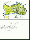
Herm Island MAP Bailiwick Guernsey Alderney Point Homet Beach Whale Old Postcard
Vintage Colour Postcard. Channel Islands. The Island of Herm. Bailiwick Guernsey. MAP showing Alderney Point, Homet, Shells, Beach, Mousonmere Beach, Hermetier, The Green, Putrainez, Caquorobert, Great Russel, Percee Passage, Meulettes, Whale, Fish, Birds, Crabs, Sailing Boat Vessel. etc. / Herm Island, the loveliest and most peaceful of the Channel Islands, is famed for its beauty and lovely dry sandy beaches. It lies only 25 minutes from St. Peter Port, Guernsey, and is easily reached by means of the Herm Ferry Service which operates a half-hourly service of motor launches from 10 a.m. Information and reservations from Guernsey Motors Ltd., and Guernsey Railway Co. Ltd. Albert Pier, St. Peter Port. Herm is one of the Channel Islands and part of the Bailiwick of Guernsey, located in the English Channel, north-west of France and south of England. It is 1.5 miles (2.4 km) long and under 0.5 miles (0.80 km) wide; orientated north-south, with several stretches of sand along its northern coast. Guernsey lies to the west and Jersey to the south-east, and the smaller island of Jethou is just off the south-west coast.
|
|